 |
|||||||||||||||||||||||||||||||||||||||||||||||||||||||||||||||||||||||||||||||||||||||||||||||||||||||||||||||||||||||||||||||||||||||||||||||||
|
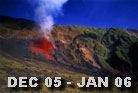
December 2005/ January 2006
|
|||||||||||||||||||||||||||||||||||||||||||||||||||||||||||||||||||||||||||||||||||||||||||||||||||||||||||||||||||||||||||||||||||||||||||||||||
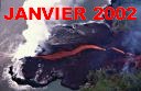
| After the short eruption of November 29th 2005, the summit area inflated and the sismicity had the Volcanologic Observatory to deduce an upcoming eruption before the end of the year 2005. On December 26th, early afternoon, a sismic crisis alerts the volcanologists of an imminent eruption. Around 4pm, the sismic activity moved towards the Nez Coupé de Sainte-Rose, and a 150 meters long break opened arouns 5:15pm,close to the crater Faujas, at 2040 m of altitude. A few minutes after the beginning of the eruption, we arrived on site with Alain Gerente . This stage of the eruption stopped its activity around 8pm after 2h45, but the sismic | |||||||||||||||||||||||||||||||||||||||||||||||||||||||||||||||||||||||||||||||||||||||||||||||||||||||||||||||||||||||||||||||||||||||||||||||||
|
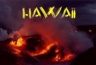
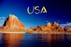
Reunion Hawaii USA Austria |
|||||||||||||||||||||||||||||||||||||||||||||||||||||||||||||||||||||||||||||||||||||||||||||||||||||||||||||||||||||||||||||||||||||||||||||||||
| crisis goes on in the area of the Nez Coupé de Sainte-Rose. Around 11pm, a second break opens at 1600meters of altitude in the rampart of Bois-Blanc situated down the Nez Coupé de Sainte-Rose, in the heights of the Osmunds Plain. The fountains of lava were particularly spectacular this night, creating a big redding cloud that could be seen till Mauritius Island, 200 kms from here. On site at 5:30 am the day after, we noticed that several exit points were still active. Under the gas pressure, a fountain of lava of 70 m high was coming out of the most active exit point. The very fluid lava flows kept their activity until the afternoon of December 28th, when the front of the flow reached 450 meters of altitude, 2,7 kilometers from the National Road. The activity weakened during the following days. Small projections from the forming crater, have been observed, as well as some lava flows mostly under 1 km long. A revival of the activity appeared on January 6th, and more between the 8th and 10th: the increase of the lava flow allowed the 4 to 5 km long flows to reach again the Grand Brûlé at 400 m high. The activity suddenly slows down during the night of the 10th to the 11th. The crater collapsed on itself and only a few samll flows couls be observed. This type of residual avtivity lasted until the afternoon of january 18th, tha day the tremor stopped its activity announcing the end of the eruption. |
|||||||||||||||||||||||||||||||||||||||||||||||||||||||||||||||||||||||||||||||||||||||||||||||||||||||||||||||||||||||||||||||||||||||||||||||||
 |
 |
 |
 |
 |
|||||||||||||||||||||||||||||||||||||||||||||||||||||||||||||||||||||||||||||||||||||||||||||||||||||||||||||||||||||||||||||||||||||||||||||
 |
 |
 |
 |
 |
|||||||||||||||||||||||||||||||||||||||||||||||||||||||||||||||||||||||||||||||||||||||||||||||||||||||||||||||||||||||||||||||||||||||||||||
 |
 |
 |
 |
 |
|||||||||||||||||||||||||||||||||||||||||||||||||||||||||||||||||||||||||||||||||||||||||||||||||||||||||||||||||||||||||||||||||||||||||||||
 |
 |
 |
 |
 |
|||||||||||||||||||||||||||||||||||||||||||||||||||||||||||||||||||||||||||||||||||||||||||||||||||||||||||||||||||||||||||||||||||||||||||||
 |
 |
 |
 |
 |
|||||||||||||||||||||||||||||||||||||||||||||||||||||||||||||||||||||||||||||||||||||||||||||||||||||||||||||||||||||||||||||||||||||||||||||
 |
 |
||||||||||||||||||||||||||||||||||||||||||||||||||||||||||||||||||||||||||||||||||||||||||||||||||||||||||||||||||||||||||||||||||||||||||||||||
|
|||||||||||||||||||||||||||||||||||||||||||||||||||||||||||||||||||||||||||||||||||||||||||||||||||||||||||||||||||||||||||||||||||||||||||||||||


GEOGRAPHIE
La Réunion n'est que la partie émergée d'une énorme construction volcanique de 7000m de hauteur reposant sur le plancher océanique à 4000m de profondeur. L'émergence s'est effectuée il y a environ 3 millions d'années.
Ile tropicale située dans le sud-ouest de l'Océan Indien
Réunion / Paris (France): 9180 km
Réunion / Port-Louis (Ile Maurice): 210 km :
Réunion / Tananarive (Madagascar): 880 km
Réunion / Johannesburg (Afrique du Sud): 2825 Km
Superficie : 2512 km2
Longueur : 70 km - Largeur : 50 km
Circonférence : 240 km
HISTOIRE
La Réunion n'a pas connu de préhistoire humaine et selon le naturaliste Jean- Michel Probst, dans une approche biologique, l'homme doit être considéré comme une espèce introduite.
C'est aux Portugais que l'on doit la découverte de la Réunion (les Arabes avaient probablement déjà observé
« la montagne de feu dans la mer ») Grâce à leur longue entreprise pour contourner l'Afrique et rejoindre l'Asie(15e et 16e siècle), Pedro Mascarenhas découvrit les trois îles qui forment les Mascareignes en 1516 (Réunion, Maurice, Rodrigue). Jusqu'au 17e siècle elle fût un paradis de ravitaillement en eau douce et en viandes fraîches pour les navigateurs de l'époque qui ne restaient sur l'île que le temps de remplir les cales et de faire des réparations. Ce n'est qu'en 1665 que les Français effectuèrent le premier véritable peuplement de l'île.