 |
|||||||||||||||||||||||||||||
|
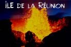
Reunion Island
|
|||||||||||||||||||||||||||||
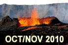
| Island situation and short description: CLICK HERE. See the fabulous last eruptions of the 20th century and the first of the 21st century !!! |
 |
Reunion Hawaii USA Austria |
|||||||||||||||||||||||||||
 |
 |
||||||||||||||||||||||||||||
 |
 |
 |
|||||||||||||||||||||||||||
|
|
|||||||||||||||||||||||||||||
|
|
|||||||||||||||||||||||||||||
|
|
|
|
|||||||||||||||||||||||||||
 |
 |
 |
 |
 |
|||||||||||||||||||||||||
|
|
|||||||||||||||||||||||||||||
|
|
|
|
|
||||||||||||||||||||||||||
 |
 |
 |
 |
||||||||||||||||||||||||||
|
|
|
|
|
|
|||||||||||||||||||||||||
 |
 |
 |
 |
 |
|||||||||||||||||||||||||
|
|
|
||||||||||||||||||||||||||||
|
|
|
|
|||||||||||||||||||||||||||
|
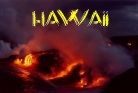
USA / HAWAII
|
 |
 |
 |
||||||||||||||||||||||||||
|
|
|
|
|
|
|
||||||||||||||||||||||||
Surface area : 2,512 sq.km (+ 30 hectares gained from lava reaching the ocean in 1986) . Maximum diameter: 70 km and length of the coastline: 207 km .
The island is characterized by numerous micro-climates : Temperatures, which are normally relatively high along the coasts, are elsewhere quite moderate in relation to the altitude .
The conditions of climate and rainfall usually undergo modifications during the austral summer when Reunion is occasionally submitted to the effects of cyclones or tropical depressions .